2 - Mapping and describing your natural resources
Natural resource mapping in the arid zone is based on a tiered system that starts at the more general bioregion level, through to land systems (also called range types) and down to land units (with smaller, more detailed descriptions).
Mapping your natural resources is important to assist in understanding and identifying areas that may require different types of grazing management.
Bioregions of the arid zone
Bioregions are defined as a land area composed of a cluster of interacting ecosystems, repeated in similar form across the landscape. The bioregions are based on factors associated with climate, geology, landforms and vegetation and are applied at a continental scale (1:1,000,000), see Figure 2.
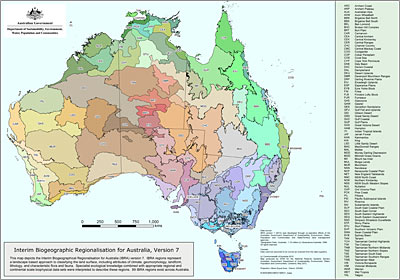
Figure 2: Interim bioregions for Australia
Below are brief descriptions of the 24 bioregions in Australia’s arid zone.
| Broken Hill Complex (BHC) | Hills and alluival fans with desert loams and red clays and calcareous red earth; supporting chenopod shrublands of Maireana spp. (bluebush), Atriplex spp. (saltbush) shrublands and open mulga (Acacia aneura) shrublands. |
|
Burt Plain (BRT) |
Plains and low rocky ranges of granites with mulga and other acacia woodlands on red earths. |
|
Carnarvon (CAR) |
A mosaic of saline alluvial plains with samphire and saltbush low shrublands, Bowgada low woodland on sandy ridges and plains, snakewood scrubs on clay flats, and tree/shrubs over hummock grasslands on and between red sand dune fields. Limestone with Acaciaspp. shrublands in the north. |
| Channel Country (CHC) |
Low hills on sediments; forb fields and Mitchell grass downs and intervening braided river systems of coolibah woodlands and lignum shrublands, includes small areas of sand plains. |
|
Coolgardie (COO) |
Mallees and shrubs on sandplains. Diverse woodlands rich in endemic eucalypts, on low hills, valley alluvials and broad plains of calcareous earths. |
|
Davenport Murchison Ranges (DMR) |
Low, rugged rocky hills, formed from folded volcanics and sandstone, siltstone and conglomerates, which contrast with the flat sandplain surrounds of the Tanami bioregion. Vegetation includes hummock grasslands and low open woodlands dominated by eucalypt and Acacia species. |
|
Finke (FIN) |
Arid sandplains, dissected uplands and valleys with spinifex hummock grasslands and acacia shrublands on red earths and shallow sands. |
|
Flinders Lofty Block (FLB) |
Ranges, alluvial fans and plains and some outcropping volcanics, supporting native cypress, black oak (belah) and mallee open woodlands, Eremophila and Acaciashrublands, and bluebush/saltbush chenopod shrublands on shallow, well-drained loams and moderately-deep, well-drained red duplex soils. |
|
Gascoyne (GAS) |
Rugged low sedimentary and granite ranges divided by broad flat valleys. Open mulga woodlands occur on shallow earthy loams over hardpan on the plains, with mulga scrub and Eremophila shrublands on the shallow stony loams of the ranges. In the east, characterised by extensive salt lake features supporting succulent steppes. |
|
Gawler (GAW) |
Semi-arid to arid, flat topped to broadly rounded hills of the Gawler Range Volcanics and sediments. Slopes, erosional and depositional plains and salt encrusted lake beds, with black oak (belah) and myall low open woodlands, open mallee scrub, bluebush/saltbush open chenopod shrublands and tall mulga shrublands on shallow loams, calcareous earths and hard red duplex soils. |
|
Gibson Desert (GID) |
Lateritised upland on flat-lying sandstones of Canning Basin. Mulga over Triodia basedowii on 'buckshot' plains. Mixed shrub steppe of Acacia, Hakea and Grevilleaover Triodia pungens on red sand plains and dune fields. Alluvial plains associated with drainage features support coolabah woodlands over bunch grasses. |
|
Great Sandy Desert (GSD) |
Mainly tree steppe grading to shrub steppe in south; comprising open hummock grassland of Triodia pungens with scattered trees of Owenia reticulata and Bloodwoods, and shrubs of Acacia spp., Grevillea wickhamii and G. refracta, on red longitudinal sand dune fields. Casuarina decaisneana (desert oak) occurs in the far east of the region. Gently undulating uplands support shrub steppe such as Acacia pachycarpa shrublands over Triodia pungens hummock grass. Extensive salt lake chains with samphire low shrublands, and Melaleuca glomerata, M. lasiandra shrublands. |
|
Great Victoria Desert (GVD) |
Sand-ridge desert of deep aeolian sands. Tree steppe of Eucalyptus gongylocarpa, mulga and E. youngiana over hummock grassland dominated by Triodia basedowii. |
|
Little Sandy Desert (LSD) |
Red dune fields with sandstone ranges. Shrub steppe of acacias, and grevilleas over on sandy surfaces. Sparse shrub-steppe over Triodia basedowii on stony hills, with river gum communities and bunch grasslands on alluvial deposits in and associated with ranges. |
|
MacDonnell Ranges (MAC) |
High ranges and foothills covered with spinifex hummock grassland, sparse Acaciashrublands and woodlands along watercourses. |
|
Mitchell Grass Downs (MGD) |
Undulating downs on shales and limestones; Astrebla spp. grasslands and Acacia low woodlands on grey and brown cracking clays. |
|
Mulga Lands (MUL) |
Undulating plains and low hills on sediments; red earths. Acacia aneura shrublands and low woodlands. |
|
Murchison (MUR) |
Mulga low woodlands, often rich in ephemerals, on hardpan washplains. Surfaces associated with the drainage occur throughout with hummock grasslands on sandplains, saltbush shrublands on calcareous soils and samphire low shrublands. Areas of red sandplains with mallee-mulga over hummock grasslands. |
|
Nullarbor (NUL) |
Tertiary limestone plain; with bluebush - saltbush steppe in central areas; low open woodlands of myall over bluebush in peripheral areas, including Myoporum platycarpum and E. oleosa. |
|
Pilbara (PIL) |
Mulga low woodland over bunch grasses on fine textured soils and snappy gum over Triodia brizoides on skeletal sandy soils of the ranges. Alluvial plains, river frontages and Salt marsh, mulga-bunch grass, and short grass communities on alluvial plains. |
|
Simpson Strzelecki Dunefields (SSD) |
Arid dunefields and sandplains with sparse shrubland and spinifex hummock grassland, and cane grass on deep sands along dune crests. Large salt lakes, notably Lake Eyre and many clay pans dispersed among the dunes. Several significant arid rivers terminate at Lake Eyre, Cooper Creek and Warburton River. They are fringed with coolibah and redgum woodlands. |
|
Stony Plains (STP) |
Arid stony silcrete tablelands and gibber and gypsum plains with sparse low chenopod shrublands on duplex soils and calcareous earths, dissected by large arid drainage systems with coolibah and redgum on cracking clays along riverbanks of numerous creeks and rivers. |
|
Tanami (TAN) |
Mainly red sandplains overlying exposed hills and ranges. The sandplains support mixed shrub steppes of Hakea suberea, desert bloodwood, Acacia and grevillea over Triodia pungens hummock grasslands. Wattle scrub over T. pungens hummock grass communities occur on the ranges. Alluvial and calcareous deposits occur throughout. |
|
Yalgoo (YAL) |
This region is an interzone between south-western bioregions and Murchison. It is characterised by low woodlands to open woodlands of Eucalyptus, Acacia and Callitris on red sandy plains. |
Land systems
Land systems are the most common way to describe vegetation communities in the Australian arid zone. Land systems group together land units of common vegetation, soil and slope at a scale appropriate for land management. Land system maps and the descriptions and assessments of land condition have become primary information for pastoralists enabling the land to be managed according to the types of country. Each land system, with its soils and vegetation, responds differently to seasonal rainfall as well as to impacts from grazing, other land use pressures, events and destabilising influences.
Land systems across the arid zone have been progressively classified and mapped, according to the geomorphology (land forms), soil and vegetation. Successive surveys used vegetation mapping, geological survey maps and information from various other surveys. Land system mapping has also been improved through the use of spatial information from remote sensing, including Landsat and other satellite data.
The basis of the land system groupings has evolved over the years to meet practical land use and management considerations.
Land system mapping is available for parts of the arid zone including WA, SA, NT, NSW and parts of Queensland.
Contact your Agriculture or Primary Industries departments to determine extent and availability of land system maps for your property.